Q 28 / 32
UPSC CSE Prelims 1999
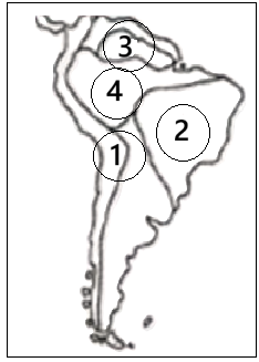
Physical regions marked as 1, 2, 3, & 4 on the given map are respectively:
EXPLANATION
Correct Option (A):
The physical regions marked on the map are identified as follows:
- Region 1: Andes Mountains. This major fold mountain range extends along the western margin of South America, from Venezuela in the north to Chile and Argentina in the south.
- Region 2: Brazilian Shield (or Brazilian Highlands). Located in the eastern part of Brazil, this is an extensive ancient crystalline plateau.
- Region 3: Guyana Highlands. Situated in the northern part of South America, north of the Amazon Basin, this region comprises plateaus and mountainous terrain.
- Region 4: Amazon Basin. This vast lowland area spans across northern Brazil and surrounding countries, drained by the Amazon River and characterized by tropical rainforest.
Incorrect Options:
- (B) This option incorrectly places the Guyana Highlands (Region 3) before the Brazilian Shield (Region 2) in the given sequence.
- (C) This option incorrectly identifies Region 1 as the Amazon Basin and Region 4 as the Andes, reversing their actual geographical positions on the map.
- (D) This option incorrectly identifies Region 1 as the Guyana Highlands. Region 1 clearly depicts the Andes Mountains, which form the western margin of the continent.
SOURCECertificate Physical and Human Geography by G.C. Leong, Chapter 19: South America