UPSC CSE Prelims 1998
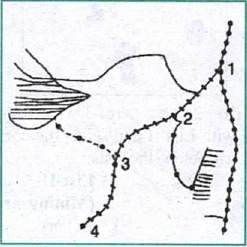
The four railway junctions shown by numerals 1, 2, 3, 4 on the rough outline map of Gujarat are respectively:
EXPLANATION
Correct Option
The railway junctions shown by numerals 1, 2, 3, and 4 on the map of Gujarat correspond to Mahesana, Surendranagar, Rajkot, and Junagadh, respectively.
- Numeral 1 represents Mahesana, a significant railway junction located in north-central Gujarat.
- Numeral 2 indicates Surendranagar, situated to the west of Mahesana, serving as a key rail link to the Saurashtra region.
- Numeral 3 denotes Rajkot, a major railway hub and prominent city in central Saurashtra.
- Numeral 4 corresponds to Junagadh, positioned in the southwestern part of the Saurashtra peninsula.
These cities form a logical sequence of railway junctions from north-central Gujarat towards the southwest of the Saurashtra region.
Incorrect Options
Options (a), (c), and (d) are incorrect because the cities listed do not accurately correspond to the geographical locations marked by the numerals 1, 2, 3, and 4 on the map, either due to incorrect sequencing or inaccurate placement. For instance, Palanpur (in options a and c) is located further north than point 1. Kandla (in option c) is a port on the Gulf of Kutch, not an inland junction depicted. Ahmedabad and Vadodara (in options a and d) are major cities but their positions do not align with the sequence shown. Broach (Bharuch, in option d) is situated much further south along the coast than any of the marked points.