Q 32 / 32
UPSC CSE Prelims 1996
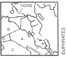
The rough outline map shows a portion of the Middle East. The countries labelled A, B, C and D are respectively:
EXPLANATION
Correct Option
The provided map outlines a segment of the Middle East. The identification of the countries labeled A, B, C, and D is based on their relative geographical positions:
- Country A is Iraq, centrally located and identifiable by the presence of the Tigris and Euphrates river basins.
- Country B, situated to the northwest of Iraq, is Syria.
- Country C, positioned directly south of Iraq, is Saudi Arabia.
- Country D, located to the west of Iraq and southeast of Syria, is Jordan.
Incorrect Options
- Option 1 (Syria, Iraq, Jordan and Saudi Arabia) is incorrect because it misidentifies Country A as Syria and Country B as Iraq, which is contrary to their actual geographical placement.
- Option 2 (Syria, Iraq, Saudi Arabia and Jordan) is incorrect as it similarly misplaces Syria and Iraq, assigning Syria to position A instead of Iraq.
- Option 4 (Iraq, Syria, Jordan and Saudi Arabia) is incorrect because it interchanges the positions of Country C and Country D, incorrectly identifying C as Jordan and D as Saudi Arabia.